Cloudburst and Concrete Pakistans Divided Flood Crisis
By Hassaan Ahmad Awan
Cloudburst & Concrete: Pakistan’s Divided Flood Crisis
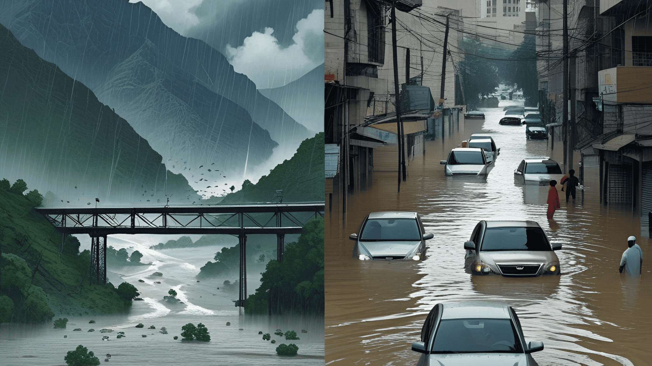
The summer of 2025 has once again proven that Pakistan is caught in the grip of a climate paradox: a nation rich in geographical diversity but brittle in its resilience against natural disasters. From the northern mountains to the sprawling southern megacity of Karachi, two very different faces of the same tragedy have emerged—catastrophic cloudbursts in the highlands and crippling urban flooding in lowland cities. Both reveal a common thread: inadequate infrastructure, short-term planning, and a failure to align adaptation strategies with geography.
In recent weeks, flash floods triggered by cloudbursts in Khyber Pakhtunkhwa have claimed hundreds of lives, washing away entire villages, bridges, and rescue operations. Meanwhile, Karachi recorded its heaviest rainfall in decades, with major roads submerged, drainage systems collapsing, and the city grinding to a halt. On the surface, these crises look distinct. But together, they highlight how Pakistan’s topography—mountains, plains, and coastlines—demands tailored climate adaptation, not a one-size-fits-all approach.
Cloudbursts in the Mountains: When Skies Turn Deadly
A cloudburst is no ordinary rainfall. It is an intense downpour, often exceeding 100 millimeters within an hour, concentrated over a small geographical pocket. In the mountainous terrain of Pakistan’s north, such rainfall cannot disperse gradually. Instead, it funnels violently through valleys, triggering flash floods, landslides, and devastation in communities perched on steep slopes.
In August 2025, a series of cloudbursts in Shangla, Swat, and Chitral swept away homes and entire stretches of road within minutes. More than 320 lives were lost, and thousands displaced. The tragedy was compounded when a rescue helicopter crashed in heavy weather, underscoring both the intensity of the storm and the vulnerability of relief operations.
This crisis illustrates a brutal truth: in mountainous regions, infrastructure is inherently fragile. Bridges, hydropower dams, and even road networks stand precariously against the elements. Unlike cities, where poor planning exacerbates flooding, in the mountains it is often the absence of resilient design standards that turns natural rainfall into lethal disaster.
Karachi’s Urban Floods: A Crisis of Concrete
If the north suffers from too little infrastructure, Karachi suffers from too much concrete and too little planning. Once a city of waterways, wetlands, and natural drainage channels, Karachi’s rapid urban sprawl has paved over its protective systems. Rivers have been narrowed, storm drains clogged by uncollected waste, and green belts replaced with shopping plazas.
When Karachi received over 160 millimeters of rainfall in a single day this August, the city’s drainage collapsed. Thousands were stranded, businesses shut down, and hospitals were overwhelmed by waterborne diseases. Unlike the mountainous floods that sweep down from above, Karachi’s floods rise from below—water trapped by encroached nullahs and blocked drainage.
Urban flooding in Karachi is not caused merely by the rain. It is the consequence of decades of unregulated urbanization, weak municipal governance, and politicized water management. What could have been a manageable storm became a humanitarian crisis because the city’s natural drainage has been systematically destroyed.
A Shared Vulnerability: Different Landscapes, Same Weakness
At first glance, a cloudburst in Swat and a flood in Karachi seem like entirely different phenomena. But they both expose the same fundamental issue: Pakistan builds without resilience.
-
In the mountains, infrastructure is underbuilt—bridges and roads are constructed without factoring in extreme rainfall patterns or shifting riverbeds.
-
In cities, infrastructure is overbuilt but underplanned—concrete has replaced nature, leaving no breathing room for drainage and absorption.
Both cases reveal the absence of a geography-sensitive adaptation strategy. National disaster management often works with a blanket approach, focusing on relief rather than prevention. But a mountain road and a coastal megacity require radically different climate-proofing measures.
Why Climate Adaptation Must Differ Across Landscapes
Pakistan cannot afford to treat climate adaptation as a single formula. The country spans some of the world’s most diverse geographical zones: towering Himalayas, fertile Indus plains, deserts of Thar, and coastal cities along the Arabian Sea. Each faces unique climate threats.
1. Mountainous Regions
-
Resilient Infrastructure: Roads and bridges must be built to withstand flash floods, with alternative access routes in case of washouts.
-
Early Warning Systems: Communities need localized, real-time rainfall monitoring to evacuate ahead of cloudbursts.
-
Community Preparedness: Villages in high-risk valleys require training in rapid evacuation, first aid, and flood-safe construction practices.
2. Urban Centers
-
Restoring Natural Drainage: Reviving Karachi’s nullahs, wetlands, and green spaces is critical.
-
Smart Drainage Design: Stormwater systems must be redesigned to handle record-breaking rainfall, with regular maintenance.
-
Regulated Urban Expansion: A long-term urban master plan, free from political capture, is needed to prevent encroachments.
3. Coastal & Deltaic Areas
-
Rising sea levels and saltwater intrusion add another layer of risk. Here, adaptation requires coastal embankments, mangrove restoration, and climate-smart urban planning in cities like Gwadar and Thatta.
By tailoring adaptation to geography, Pakistan can shift from reactive disaster response to proactive climate resilience.
Policy Blind Spots: Why Change Has Been Slow
Pakistan’s climate vulnerabilities are not new. The 2010 super floods, which submerged a fifth of the country, should have been a turning point. Instead, political cycles, donor dependency, and institutional fragmentation have left disaster management underfunded and poorly coordinated.
Two blind spots stand out:
-
Short-Termism: Governments prioritize relief optics over long-term resilience. Trucks of rations win more votes than invisible investments in drainage or slope stabilization.
-
Centralization: Decision-making often ignores local contexts. A national “flood policy” may look good on paper but fails when applied equally to Gilgit’s valleys and Karachi’s industrial zones.
Without addressing these gaps, Pakistan will remain trapped in a cycle of annual disaster, each one worse than the last.
Toward a Geography-Sensitive Climate Strategy
A forward-looking approach must begin with data and decentralization. Climate models should feed into district-level adaptation plans, ensuring that local governments can tailor solutions to their unique landscapes. Universities, hydrologists, and urban planners must be integrated into this planning process, not just bureaucrats and contractors.
Additionally, Pakistan must invest in nature-based solutions alongside engineering fixes. Mangroves, wetlands, forests, and terraced agriculture offer resilience that concrete alone cannot provide. A mountain valley with healthy forests absorbs rainfall differently from one stripped bare by logging. A city with wetlands survives heavy rain better than one paved over in asphalt.
A Nation at a Crossroads
Pakistan’s divided flood crisis is not merely about water. It is about governance, planning, and foresight. Cloudbursts in the mountains and concrete floods in the cities tell the same story: a state that reacts to disasters instead of preparing for them.
The question is no longer whether extreme weather will strike—it is how Pakistan will adapt to it. The choice lies between repeating the cycle of devastation or embracing a new model of climate governance rooted in geography, science, and community resilience.
Conclusion
As Pakistan mourns the lives lost to cloudbursts in the north and urban floods in the south, the urgency for climate adaptation tailored to landscapes has never been greater. The mountains need resilient engineering and localized preparedness. The cities need restored nature and reformed governance. And the nation as a whole needs to recognize that climate change will not wait for political stability.
If Pakistan does not adapt its infrastructure to its geography, the next storm—whether in the mountains or the megacities—will once again wash away lives, livelihoods, and fragile hope.
✍️ Hassaan Ahmad Awan
Writer, columnist, and blogger at hassaanahmadawan.com — exploring Pakistan’s environment, society, and culture through a lens of history and policy.
Urdu Version Of Column :
کلاؤڈ برسٹ اور کنکریٹ: پاکستان کا منقسم سیلابی بحران
سال 2025 کی گرمیوں نے ایک بار پھر یہ ثابت کر دیا کہ پاکستان ماحولیاتی تضاد کا شکار ہے: ایک ایسا ملک جو جغرافیائی تنوع سے مالا مال ہے لیکن قدرتی آفات کے مقابلے میں نہایت نازک ہے۔ شمالی پہاڑوں سے لے کر جنوبی میگا سٹی کراچی تک، ایک ہی المیے کی دو مختلف شکلیں سامنے آئیں—بلند پہاڑوں میں ہلاکت خیز کلاؤڈ برسٹ اور میدانی شہروں میں شہری سیلاب۔ دونوں نے ایک مشترکہ نکتہ اجاگر کیا ہے: ناکافی انفراسٹرکچر، قلیل المدتی منصوبہ بندی، اور یہ ناکامی کہ موسمیاتی موافقت کو جغرافیے کے حساب سے ڈھالا جائے۔
گزشتہ ہفتوں میں خیبر پختونخواہ میں کلاؤڈ برسٹ سے پیدا ہونے والے فلیش فلڈز نے سینکڑوں جانیں لے لیں، پورے دیہات، پل اور سڑکیں بہا دیں۔ دوسری طرف کراچی میں دہائیوں کی سب سے زیادہ بارش ریکارڈ ہوئی، سڑکیں ڈوب گئیں، نکاسی آب کا نظام بیٹھ گیا، اور پورا شہر مفلوج ہو گیا۔ بظاہر یہ دونوں بحران الگ دکھائی دیتے ہیں، لیکن حقیقت میں یہ اس بات کی نشاندہی کرتے ہیں کہ پاکستان کے متنوع جغرافیے کو مختلف قسم کے موسمیاتی حل درکار ہیں، نہ کہ ایک ہی فارمولہ۔
پہاڑوں میں کلاؤڈ برسٹ: جب آسمان موت برساتا ہے
کلاؤڈ برسٹ عام بارش نہیں۔ یہ ایک شدید بارش ہے، جو اکثر ایک گھنٹے میں 100 ملی میٹر سے زائد ایک چھوٹے علاقے پر برسا دیتی ہے۔ پاکستان کے شمالی پہاڑی علاقوں میں زمین کی ڈھلوان اور تنگ وادیوں کی وجہ سے یہ بارش جذب نہیں ہو پاتی بلکہ وادیوں سے تیزی کے ساتھ بہتی ہے، جس کے نتیجے میں فلیش فلڈز، لینڈ سلائیڈز اور دیہات کی تباہی واقع ہوتی ہے۔
اگست 2025 میں، شانگلہ، سوات اور چترال میں کلاؤڈ برسٹ کے بعد آنے والے فلیش فلڈز نے چند منٹوں میں گھروں اور سڑکوں کو بہا دیا۔ 320 سے زائد افراد جاں بحق ہوئے اور ہزاروں بے گھر ہو گئے۔ المیہ اس وقت مزید بڑھ گیا جب ایک ریسکیو ہیلی کاپٹر خراب موسم میں گر کر تباہ ہو گیا۔
یہ بحران ایک تلخ حقیقت کو اجاگر کرتا ہے: پہاڑی علاقوں میں انفراسٹرکچر بنیادی طور پر نازک ہے۔ پل، ہائیڈرو پاور ڈیمز اور سڑکیں قدرتی مظاہر کے سامنے غیر محفوظ ہیں۔ شہروں کے برعکس، جہاں ناقص منصوبہ بندی سے سیلاب بڑھتا ہے، پہاڑوں میں مسئلہ پائیدار ڈیزائن معیارات کی کمی ہے، جو قدرتی بارش کو مہلک آفت میں بدل دیتا ہے۔
کراچی کے شہری سیلاب: کنکریٹ کا قید خانہ
اگر شمال میں مسئلہ انفراسٹرکچر کی کمی ہے تو کراچی کا مسئلہ ضرورت سے زیادہ کنکریٹ اور بے منصوبہ بندی ہے۔ کبھی یہ شہر ندی نالوں، آبی گزرگاہوں اور قدرتی نکاسی آب کے نظام سے مالا مال تھا، لیکن تیزی سے ہونے والی آبادی اور تعمیرات نے ان سب کو ختم کر دیا۔ نالوں کو تنگ کر دیا گیا، کچرے نے نکاسی کو بند کر دیا، اور سبزہ زار شاپنگ پلازوں میں بدل گئے۔
جب اگست میں کراچی پر ایک دن میں 160 ملی میٹر سے زیادہ بارش برسی، تو نکاسی آب کا نظام بیٹھ گیا۔ ہزاروں لوگ پھنس گئے، کاروبار رک گئے اور اسپتال پانی سے پیدا ہونے والی بیماریوں سے بھر گئے۔ پہاڑوں کے سیلاب اوپر سے نیچے آتے ہیں، لیکن کراچی کے سیلاب نیچے سے اوپر اٹھتے ہیں—پانی جو کنکریٹ اور بند نالوں میں پھنس جاتا ہے۔
کراچی کا شہری سیلاب صرف بارش کا نتیجہ نہیں بلکہ دہائیوں کی بے قابو شہری پھیلاؤ، کمزور بلدیاتی حکومت اور سیاست زدہ پانی کے انتظام کا انجام ہے۔
ایک مشترکہ کمزوری: مختلف منظرنامے، ایک ہی کمزوری
بظاہر سوات کا کلاؤڈ برسٹ اور کراچی کا سیلاب مختلف نظر آتے ہیں، لیکن دونوں ایک ہی بنیادی مسئلہ ظاہر کرتے ہیں: پاکستان منصوبہ بندی کے بغیر تعمیر کرتا ہے۔
-
پہاڑوں میں انفراسٹرکچر کمزور اور ناکافی ہے—پل اور سڑکیں بغیر اس سوچ کے بنائی جاتی ہیں کہ بارش کے پیٹرن بدل سکتے ہیں۔
-
شہروں میں انفراسٹرکچر حد سے زیادہ ہے لیکن منصوبہ بندی کے بغیر—قدرتی آبی گزرگاہوں کو ختم کر کے کنکریٹ بچھا دیا گیا ہے۔
دونوں صورتوں میں یہ کمی ایک ہی بات دکھاتی ہے: جغرافیہ کے مطابق موسمیاتی حکمت عملی کا فقدان۔
موسمیاتی موافقت جغرافیے کے مطابق کیوں ضروری ہے؟
پاکستان موسمیاتی موافقت کو ایک ہی فارمولے کے طور پر نہیں اپنا سکتا۔ ملک کے پاس دنیا کے سب سے متنوع جغرافیائی علاقے ہیں: بلند پہاڑ، زرخیز میدان، ریگستان اور ساحلی شہر۔ ہر ایک کو مختلف خطرات لاحق ہیں۔
1. پہاڑی علاقے
-
پائیدار انفراسٹرکچر: سڑکیں اور پل ایسے ڈیزائن کیے جائیں جو فلیش فلڈز کو سہہ سکیں۔
-
ابتدائی انتباہی نظام: بارش کی بروقت اطلاعات کے ذریعے مقامی آبادی کو نکالا جا سکے۔
-
مقامی تیاری: دیہات کو فوری انخلا اور سیلاب محفوظ تعمیرات کی تربیت دی جائے۔
2. شہری مراکز
-
قدرتی نکاسی کی بحالی: کراچی کے نالوں، آبی گزرگاہوں اور سبزہ زاروں کو بحال کرنا ضروری ہے۔
-
سمارٹ نکاسی ڈیزائن: جدید طرز کے طوفانی پانی کے نظام، باقاعدہ صفائی کے ساتھ۔
-
شہری پھیلاؤ پر قابو: طویل المدتی شہری ماسٹر پلان جسے سیاسی اثر و رسوخ سے آزاد رکھا جائے۔
3. ساحلی و ڈیلٹائی علاقے
-
بڑھتے ہوئے سمندری پانی اور کھارے پن سے نمٹنے کے لیے سمندری حفاظتی بند، مینگرووز کی بحالی، اور ساحلی شہروں میں موسمیاتی منصوبہ بندی ضروری ہے۔
پالیسی کی خامیاں: تبدیلی کیوں سست ہے؟
پاکستان کی ماحولیاتی کمزوریاں نئی نہیں۔ 2010 کا سپر فلڈ ایک اہم موڑ ہونا چاہیے تھا، لیکن سیاسی چکروں، بیرونی امداد پر انحصار اور ادارہ جاتی تقسیم نے ڈیزاسٹر مینجمنٹ کو کمزور اور غیر منظم رکھا۔
دو بڑی خامیاں ہیں:
-
قلیل المدتی سوچ: حکومتیں فوری ریلیف پر زیادہ توجہ دیتی ہیں۔
-
مرکزی نظام: فیصلے اکثر مقامی حالات کو نظرانداز کرتے ہیں۔
ایک جغرافیہ دوست موسمیاتی حکمت عملی کی ضرورت
ایک جدید حکمت عملی کی بنیاد ڈیٹا اور غیرمرکزی نظام پر ہونی چاہیے۔ موسمیاتی ماڈلز کو ضلعی سطح کے منصوبوں میں شامل کیا جانا چاہیے۔ جامعات، ہائیڈرولوجسٹس اور شہری منصوبہ سازوں کو اس عمل میں شریک کرنا ضروری ہے۔
پاکستان کو انجینئرنگ کے ساتھ ساتھ قدرتی حل بھی اپنانے ہوں گے۔ مینگرووز، دلدلی علاقے، جنگلات اور ٹیرس فارمنگ وہ قوت ہیں جو صرف کنکریٹ سے حاصل نہیں کی جا سکتیں۔
ایک دو راہے پر کھڑا ملک
پاکستان کا منقسم سیلابی بحران محض پانی کا نہیں بلکہ حکمرانی، منصوبہ بندی اور بصیرت کا بحران ہے۔ پہاڑوں میں کلاؤڈ برسٹ اور شہروں میں شہری سیلاب ایک ہی کہانی سناتے ہیں: ایک ایسی ریاست جو تیاری کے بجائے ردِعمل پر اکتفا کرتی ہے۔
سوال یہ نہیں رہا کہ کب بارش آئے گی بلکہ یہ ہے کہ پاکستان اس کے مطابق ڈھلنے کے لیے کیا کرے گا۔ انتخاب یہی ہے: یا تو ہر سال تباہی دہرائی جائے یا پھر ایک نیا ماڈل اپنایا جائے جس کی بنیاد جغرافیہ، سائنس اور مقامی استحکام پر ہو۔
نتیجہ
جیسا کہ پاکستان شمال میں کلاؤڈ برسٹ اور جنوب میں شہری سیلاب کی ہلاکتوں پر سوگوار ہے، یہ حقیقت پہلے سے زیادہ واضح ہے کہ موسمیاتی موافقت کو جغرافیائی بنیادوں پر ڈھالنا ہوگا۔ پہاڑوں کو مضبوط انفراسٹرکچر اور مقامی تیاری درکار ہے۔ شہروں کو قدرتی نظام کی بحالی اور بہتر حکمرانی چاہیے۔ اور ملک کو مجموعی طور پر یہ تسلیم کرنا ہوگا کہ موسمیاتی تبدیلی سیاست کا انتظار نہیں کرے گی۔
اگر پاکستان نے اپنے جغرافیے کے مطابق منصوبہ بندی نہ کی تو اگلا طوفان—چاہے پہاڑوں میں ہو یا میگا شہروں میں—پھر سے زندگیاں، روزگار اور امیدیں بہا لے جائے گا۔
✍️ حسان احمد اعوان
مصنف، کالم نگار اور بلاگر، hassaanahmadawan.com — پاکستان کے ماحول، معاشرت اور ثقافت کو تاریخ اور پالیسی کے تناظر میں بیان کرتے ہیں۔
Frequently Asked Questions (FAQs) on Pakistan’s Flood Crisis
Q1: What is a cloudburst, and why is it dangerous in Pakistan’s mountains?
A cloudburst is an extremely heavy rainfall event, often exceeding 100 mm per hour in a small area. In Pakistan’s northern mountains, steep valleys and fragile slopes cannot absorb such intense rain, leading to sudden flash floods, landslides, and destruction of villages.
Q2: Why does Karachi face severe urban flooding after heavy rains?
Karachi suffers from unplanned urbanization, clogged drainage systems, and encroached waterways. Natural nullahs and wetlands that once absorbed rainwater have been paved over with concrete. As a result, even moderate rainfall can flood streets, homes, and businesses.
Q3: How does Pakistan’s geography make it more vulnerable to floods?
Pakistan has diverse landscapes—mountains, plains, deserts, and coastal areas—each facing unique climate threats. Mountains face cloudbursts and landslides, plains experience riverine flooding, cities endure drainage failures, and coastal areas battle rising seas. This diversity requires region-specific adaptation strategies.
Q4: What measures can reduce flood disasters in Pakistan’s cities?
Key solutions include restoring natural drainage channels, investing in modern stormwater systems, regulating urban expansion, and enforcing building codes. Cities like Karachi need sustainable urban planning that works with nature rather than against it.
Q5: How can Pakistan prepare better for climate change and floods?
Pakistan must adopt a geography-sensitive approach, decentralize disaster management, strengthen early warning systems, and integrate nature-based solutions such as mangrove restoration, terracing, and reforestation. Only a proactive, science-driven strategy can reduce future losses.
